18,72€
DeliveryThu, 19 Sep - Mon, 23 Sep
+5,00 €shipping cost
Skroutz Buyers Protection
Set the delivery location to see products according to your choice.


Skroutz Buyers Protection
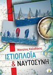
Scientific Books


Hobbies & Leisure Books


Hobbies & Leisure Books


Hobbies & Leisure Books


Hobbies & Leisure Books


Hobbies & Leisure Books
Prices are calculated for:Κύπρος, Other Payment Options
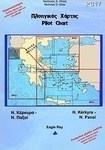
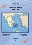
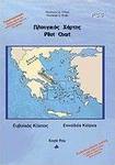
The series of Nautical Charts consists so far of the following maps, with the aim of covering the Greek area with 23 maps + 3 general ones:
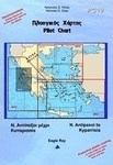
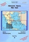
-PC1 Saronic Gulf
-PC2 Eastern Peloponnese
-PC3 Northern Cyclades
-PC4 Southwestern Cyclades
-PC5 Southeastern Cyclades
-PC6 Evian Gulf
-PC7 Corinthian Gulf
-PC8 Patraikos Gulf - Kefalonia
They are enriched with navigational information regarding:
-Dangers, reefs, instructions for narrow passages, shooting fields, etc.
-Currents and their characteristics
-Winds, peculiarities, and their frequency, etc.
-Bearings for lighthouses, bays, reefs, etc.
-Waypoints
-Official and local names
-Protection of anchorages from adverse weather conditions
The back side of the map contains:
-Ports and landmarks of the area
-Photos of ports/bays and recognition points (area configuration, points
on the horizon, etc.)
-Distances between ports/bays
They are laminated on both sides to resist water, tearing, and color fading.
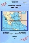
From O. Vasilikis (Lefkada) to Rion-Antirion Bridge
Includes: Patraikos Gulf and Ionian Sea
Islands of Kefalonia, Ithaca, Meganisi, Kalamos, and Kastos
Language: Greek and English
Size (unfolded): 100 x 70 cm
Specifications are collected from official manufacturer websites. Please verify the specifications before proceeding with your final purchase. If you notice any problem you can report it here.
Those users who have this product can help you
Ask for the product Technology
 Home & Garden
 Fashion
 Sports & Outdoors
 Health - Beauty
 Baby & Kid
 Auto - Moto
 Business - B2B
 Books
Books