6,50€
DeliveryWed, 24 Jul - Fri, 26 Jul
+5,00 €shipping cost
Sold by
Stock 2 pieces
Skroutz Buyers Protection
Set the delivery location to see products according to your choice.


Sold by
Stock 2 pieces
Skroutz Buyers Protection

Hobbies & Leisure Books
Hobbies & Leisure Books

Hobbies & Leisure Books


Hobbies & Leisure Books


Prices are calculated for:Κύπρος, Other Payment Options
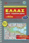
The Cycladic islands are the major tourist attraction of Greece and as such are usually described in a general way (white houses, colorful boats, and the endless blue of the sea). However, each of these fragments of the old Aegean has its own character, its often unknown interior, its history. These peculiarities invite you to get to know them through the maps of "Anavasi", through road trips, and especially through the old web of paths that is still maintained in good condition on many islands.
The "Topo" series is the latest step in the long evolution of the cartographic work of "Anavasi".
The "Topo" series includes maps in scales 1:100,000, 1:50,000, 1:25,000, and 1:10,000. The maps are constructed in the Greek Geodetic Reference System (EGSA 87), the national geodetic system that was implemented to meet the needs of large land surveying and mapping projects in the country.
Considering that a map is a tool on which the user's safety sometimes depends, "Anavasi" strives to provide the best and most accurate cartographic material. Thus, all the work (construction of the base, collection and representation of field data, final map composition) is done with defined and strict quality and accuracy specifications, ensuring the highest possible accuracy for these specific scales.
In the "Topo" series of "Anavasi", two coordinate systems are displayed:
- The square grid every 1 km in the Greek Geodetic Reference System. It is a complete rectangular grid (orange lines). The projected coordinates of EGSA are expressed in meters.
- The crosses of geographic coordinates every 1 minute in WGS84. These are the intersection points of meridians and parallels of the global geodetic reference system that have been displayed on the map.
If you use the map in combination with a GPS, you can locate your position based on the coordinates provided by the GPS without changing any settings.
Specifications are collected from official manufacturer websites. Please verify the specifications before proceeding with your final purchase. If you notice any problem you can report it here.
1 user has this product and can help you
Ask for the product